Artist:Utagawa Hiroshige
Medium: Woodblock print
Geograhical Locations:
Dates:1st month of 1857
Dimensions: Sheet: 14 3/16 x 9 1/4 in. (36 x 23.5 cm) Image: 13 3/8 x 8 3/4 in. (34 x 22.2 cm)
Collections:
Exhibitions:
Accession Number: 30.1478.116
Image: 30.1478.116_PS20.jpg,
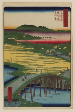
Catalogue Description: This view looks north over the Kanda Aqueduct. The gold area was known as Hikawa Ricefields, after the Hikawa Shrine, whose roof can be seen under the red cloud band. In the distance is a bluff where Gakushuin University is presently located. The earth-covered bridge over the Kanda Aqueduct is Omokage Bridge, and the small plank bridge through the paddies is the Sugatami Bridge. There is some confusion over the two bridge names; some gazetteers claim that both names were used interchangeably for the same bridge, the one over Kanda Aqueduct. Both bridge names share the same meaning: "reflection bridge," probably derived from the large Mirror Pond (Kagaminoike) which once filled this area. Hidden in the trees, across from Hikawa Shrine, is the temple of Nanzoin. The small settlement around the temple was known as Jariba (Gravel Pit).